National Deployment Strategy for Truck Stop Electrification
project by the Texas Transportation Institute
with funding provided by the United States Environmental Protection Agency
New Report on Auxiliary Power Unit Performance Testing
Development of a NOx Verification Protocol and Actual Testing of Onboard Idle Reduction Technologies (PDF)
This report was submitted to the Houston Advanced Research Center, and summarizes results of truck idling testing and auxiliary power unit (APU) testing conducted at TTI’s Environmental and Emissions Research Facility. TTI is conducting a follow-up study with the USEPA which includes additional APU testing and the development of an APU verification protocol.
The purpose of the website is to provide public and private sector agencies with a tool to identify locations to implement truck stop electrification so that it will form part of a national network, have the greatest potential of reducing idling, and have the greatest environmental benefit. The site is also useful to identify existing electrified truck stops and candidate truck stops along the nation's major truck corridors.
Project Reports
National Deployment Strategy for Truck Stop Electrification (PDF)
preprint of the 86th Annual Meeting of the Transportation Research Board, National Research Council, Washington, D.C. 2006
In-Cab Air Quality of Trucks Air Conditioned and Kept in Electrified Truck Stop (PDF) Doh-Won Lee, Josias Zietsman, Mohamadreza Farzaneh, Wen-Whai Li, Hector A. Olvera, John M. E. Storey, and Laura Kranendonk
Implementation of Idle Reduction Technologies at Ports — Case Study Evaluation for the Port of Houston (PDF) Report Prepared for Office of Transportation and Air Quality: U.S. EPA
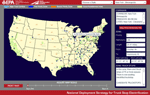
Interactive Map
The data collected for this project has been integrated into an interactive map that allows zooming, dragging, and access to the data on each of the 15 identified truck corridors and roughly 100 designated priority zones for implementation of truck stop electrification facilities. It also links to PDF maps of each of the corridors and Google Map pages for each of the zones.
To view and use the interactive map, you must have the Adobe Flash Player version 8 or newer installed.
You may choose to view the How to Use the Interactive Map page for some tips and tricks on using this resource.
Click here to go to the interactive map (this map will scale to fit the size of your window).
Or, click here to go to the fixed-size interactive map.
Some graphics may appear clearer in this version of the map.
Project Data in text and tabular format
The data displayed in the interactive map may also be accessed in the following PDF data sheets:
Project Director:
Victor McMahan — USEPA, SmartWay Technology Verification
Texas Transportation Institute Research Team:
- Joe Zietsman (Principal Investigator)
- Brian Bochner
- Juan Villa
- Reza Farzaneh
- Doh-Won Lee
- Jeremy Johnson
- Tara Ramani
- Jeff Warner
- Richard Cole
- Mark Coppock
Acknowledgements
The Research Team would like to thank Idle Aire and Shurepower (suppliers of truck stop electrification) for providing information regarding existing and planned installations as well as truck stops in general.
Please note: The research team made every effort possible to present current and accurate information here. However, there may be cases where more current and accurate information is available. If so, please let the site administrator know at zietsman@tamu.edu.